Just finished updating all the mineral photos (bigger, cleaned up backgrounds, better color balance, etc.) and also posted several new ones including the first attempt at photographing a fluorescent piece.
Feb 282011
We were in New Mexico for other reasons, but managed to visit two sites while here – both in extreme southern New Mexico, near where we were staying in Las Cruces.
September 18th
Kilibourne Hole is a “Maar” – a volcanic feature where subterranean magma came into contact with ground water near the surface. The latter flashed to steam, blowing out a hole about a mile in diameter but less than a hundred feet deep. It is located about 8 miles from the Mexican border in a very empty part of New Mexico.

Kilibourne Hole Peridot
From a couple miles away you can see the edge of the Maar as a slight broad rise on the horizon. In the interior of the hole, there is a distinct layer of volcanic basalt. Under this layer, and weathered-out elsewhere, there are volcanic “bombs” that contain little specks of gem quality Olivine, otherwise known as Peridot.

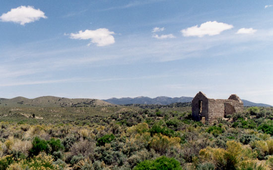
Kilibourne Hole from a Distance
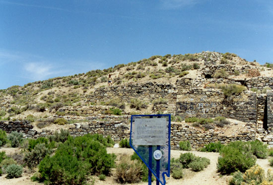
Here is a closer look at the wall from the outside. It is only about 20 feet tall and easy to walk up.

Wall of Kilibourne Hole
Here is the view into the hole from the top of the edge wall.

Interior of Kilibourne Hole
If you travel here, be very wary of rattlesnakes. We came across five rattlers in the space of about 10 minutes. Just make sure you make a lot of noise on the rocks so they either go away, or rattle so that you have a good shot at spotting one before stepping on it!

Blacktail Rattlesnake
Here you can clearly see the basalt layer. The bombs are found in the dirt beneath this layer, but it takes quite a bit of digging. We found a couple that had weathered out and fallen further down the slope and that was good enough for this trip as it was getting pretty late in the afternoon.

Basalt Layer
September 20th
The area south of Deming, New Mexico is filled with sites for geodes, including a state park dedicated to rockhounding. We spoke to a couple mineral shops in the area and finally settled on checking out a couple sites on the south edge of the Little Florida Mountains.

This is the general area. There was no obvious prospect hole or other diggings, so we just wandered the area and checked out the rocks. We found several pieces of Agate and one good Quartz & Agate Geode.

Geode Site
This is the view south from where we parked. There is supposed to be at least three dig sites here, so a more thorough search of the area is probably a good idea for a future trip.

View to the South
For this trip, we flew into Denver for a 10-day loop through Colorado. Originally I tried to rent an FJ Cruiser because I knew we’d be facing some pretty rough roads up in the mountains. Well, there are no rental agencies that have FJ’s, but it turns out Toyota rents them directly! There is only one dealer in the Denver area that does rentals, but they did not return any emails or phone calls. A little research and I found out why – there are a ton of online reviews about their poor service.
So we settled for a 4-Runner from Budget. It handled every road admirably, although we did get passed on one particularly bad stretch… by an FJ Cruiser. 🙂

Picking up the 4-Runner
The first site we wanted to hit was blue Barite near Stoneham, so we headed out onto the plains northeast from Denver to the town of Sterling – that was the nearest motel.
Dinner the first night was limited to the fast food joints still open after we arrived, but it turns out the food from Taco John’s was surprisingly good. I can strongly recommend the Super Potato Ole’s if you find yourself in the upper Midwest or on a military base, where most of their joints are located.
October 2nd
This morning we started out from Sterling and made the short drive west to Stonham. This entire region of Colorado was once buried under volcanic ash from mountain building events in the Rockies.

All of this material has been eroded away leaving the flat plains, except for a spot just north of Stoneham called the “chalk cliffs”.

Chalk Cliffs
The cliffs are not actually Chalk, but Clay. Within the Clay there are layers of Shale and Calcite, and within these, hydrothermal solutions have deposited Barite. Unfortunately, the talus from the eroding Clay has completely buried and hidden any Shale strata. There are plenty of blue Barite crystals to be found on the surface, but it is very tough to find any Shale/Calcite/Barite matrix specimens.
After a couple hours here, we continued west and up into the mountains above the town of Lyons.

We hit the mining area near Jamestown looking for Fluorite, but found that all the mines but one were in the process of reclamation. The one remaining – the Emmet Mine – is an open pit almost completely covered in Purple Fluorite, but almost all of it was weathered to a powder, so it was hard to find any good crystals.
After the Emmet Mine, we headed north through Rocky Mountain National Park, and then south to the town of Hot Sulfur Springs, were we had dinner and stayed for the night at the Riverside Hotel.
Update – The Riverside Hotel was foreclosed in mid 2010. Check the current status before you plan a trip there!
October 3rd
From Hot Sulfur Springs, we continued south on the back roads from Kremmling to State Bridge, then down route 131 to Wolcott, and along I-70 to a site just north of Gypsum with Selenite crystals.

Just north of the freeway is an area with very twisted strata of Gypsum and Selenite. Small crystals are all over the area, but we found the best pieces in two boulders that had fallen down from higher up on the cliff face.

Selenite Locality

Gypsum Strata

Selenite Containing Boulders
Just down the road from the Selenite locality is a fairly recent volcanic crater. “Recent” in this case means only 4,200 years ago. Reportedly, early cartographers used the crater as a reference point for their maps, labeling it “Dot Zero”. Today the nearby town carries the slightly worn-down name of Dotsero.

Dotsero Crater
The crater itself is about a 1/2 mile across and 1300 feet deep. The remnants of a lava flow can be found just down the hill.
We continued south for the rest of the day and stayed in Gunnison that night.
October 4th
Leaving Gunnison after a huge breakfast at the W Cafe, we headed south for a bit on Colorado 149 to a small collection of ghost towns and mine dumps along the “Gunnision Gold Belt”.

The first ghost town going from west to east, Spencer, has been mostly replaced by a ranch. There really isn’t much evidence left of mines or old buildings.

Remains of Spencer
The last one, Vulcan was unreachable because of gated private property along the road to get there. The middle one, Midway (appropriately enough), was all we could get to.

Midway Mine Dump
We checked out one dump and one prospect hole, but didn’t find much there beyond Malachite.
After this, we visited the Black Canyon of the Gunnison and then drove south to Ouray and the Box Canyon Lodge, our home for the next four days.
October 5th
We started out today by taking US-550 south, over Red Mountain Pass to Silverton. The snow started falling as we passed 10,000 feet.

Red Mountain Area
Our first rockhounding stop for the day was the Aspen Mine, just above the Animas River, a few miles from Silverton. Rockhounding Colorado lists this site as having Fluorite octohedrons.

The first obstacle is a stream that has to be forded. Fortunately the water is less than a foot deep this time of year – could be a real challenge during spring runoff.

Crossing the stream
On the way up, we passed the old tram line that runs from the Mayflower Mill down in the Animas Valley up to the Mayflower & Shenandoah Mines, perched on the mountainside at 13,300 feet.

Tram Tower
Many of the ore buckets are still present – hanging from the old cables. Not only did these bring ore down from the mine to the mill, but it is generally how the miners rode to work in the morning. Not a practice of which OSHA would have approved.

Tram Bucket
We got to a spot in the area with a few old buildings and an ore chute from the Legal Tender Mine, higher up on the hill, but the road to the Aspen Mine was not obvious.

Aspen Mine Building

Ore Chute
We finally located the road to the Aspen Mine – it was overgrown with pine trees large enough that it seems no one had come this way with a vehicle for at least 15-20 years.

After hiking down, we found the old mine entrance had been covered completely by a rock slide, and there was a decent amount of water flowing out from where the entrance would have been. This water has completely flooded a second access road lower down, and turned the top level of the dumps into a swamp. The water then forms two little waterfalls flowing down the face of the tailings pile. You can see the collapsed entrance just above and to the left of the tailings in this pic.

Aspen Mine Tailings from Animas Valley
After negotiating the water hazards, we found some pretty pieces of white Quartz with Pyrite and Bornite, and one nice round cluster of clear Quartz crystals. However, there was not a single spec of Fluorite to be found.
Later research proved that while the mine we were exploring was indeed the Aspen Mine, the book that said there was Fluorite here got it wrong. The Fluorite is to be found higher up on the Legal Tender Mine and in the chute coming down from that mine. Unfortunately, we didn’t figure this out until later, and had no opportunity to go back. Something to check on a future trip!
The next stop was further north up the Animas Valley at Eureka Gulch.

The remains of the Sunnyside Mill are located here at the foot of the gulch.

Sunnyside Mill Ruins
We took the road up behind the mill looking for Rhodenite. This road goes all the way up Eureka Gulch to the Sunnyside Mine and the remains of Lake Emma, which disappeared one day when a plug of permafrost under the lake melted and drained the entire lake into the mine. However, it started snowing pretty hard about halfway up, so we decided to just stop and look along the road. We did turn up two decent pieces of Rhodenite that must have fallen from the many trucks that carried ore down from the mines over the years.

View from above the Sunnyside Mill

Where we found the Rhodenite
That was it for rockhounding on this day, but we continued north up the Animas Valley to the ghost town of Animas Forks, which seemed to look oddly appropriate shrouded in falling snow.

Animas Forks
After this we took the road towards Engineer Pass and down to US-550 just south of Ouray. The plus side of this route is the spectacular alpine tundra scenery at the summit of the road.

Near the Engineer Pass Turnoff

Alpine Meadow near Mineral Point
The minus side is the last three miles coming down the mountains towards 550. The road quickly degrades to an E-ticket ride. We later checked it out in a 4-wheeling guide and found it rates an 8 out of 10. The photo here is not an action shot – the truck was relatively stable in this two-wheels-on-the-ground position, at least enough for me to get out and take the picture.

What Fun!
October 6th
After the trials of rock crawling the previous day, we took it easy today – did some shopping in Ouray and then hiked up to Cascade Falls (only a 1/2 mile from the end of 6th Avenue in Ouray).

Cascade Falls

Cascade Falls
After lunch we visited Box Canyon Falls (also within the Ouray city limits) and their large indigenous Chipmunk population.

Slot Canyon at Box Canyon Falls

Chipmunk #1

Chipmunk #2
October 7th
First order of business today was to follow the Camp Bird Mine Road all the way up to Yankee Boy Basin. Lots of waterfalls and nice scenery up here.
On the way back down we stopped at the very large tailings piles of the Revenue Mine. This is marked on most maps as the town site of Sneffels, now a ghost town with only one or two bulidings. At it’s height, 3,000 people lived here, more than three times the present population of Ouray.

We found good Galena, Quartz, Pyrite, Fluorite and Sphalerite pieces here.

Revenue Mine Tailings
In the afternoon we drove over Ophir Pass and into Telleride, but didn’t do any more rockhounding for the rest of the day.
October 8th
We said our goodbyes to Ouray this morning and headed south through Durango, then up US-160 towards South Fork. Along the way, we passed through Wolf Creek Pass, just north of Pagosa Springs where various geodes are to be found in a road cut of volcanic Basalt.

We managed to liberate lots of solid Agate geodes that may polish well, one nice Amethyst geode, a Chalcedony geode with paper-thin walls, and two geodes with thin white fiberous crystals within. We originally thought these were Natrolite, but I now think they are Mordenite, possibly growing over pale orange Heulandite crystals.
After this stop, we continued north to the Streamside Bed & Breakfast in Nathrop for our last three nights of vacation.
October 9th
The spot where we stayed is literally at the foot of Mount Antero, a famous Aquamarine locality. However, Antero is 14,269 feet, and the collecting area is only a couple hundred feet below the summit. This might be something we’d try in July, but not mid-October!
Instead, we drove west for a few miles to the semi-ghost town of St. Elmo (lots of old buildings, a few scattered residents), then a bit south to the Mary Murphy and Pat Murphy mines.

This was cold and windy enough, at just over 12,300 feet. The dumps had tons of Galena, a decent amount of Rhodenite, a few small crystals of light pink Rhodocrosite, and one nice piece of Azurite (at least it seems we found the only one).

Mary & Pat Murphy Mines

View from below the Dumps

Road Down from the Mines
We then came down from the mountains and over to a small hill of Rhyolite alongside the Arkansas river, just outside of Nathrop. Small vesicles in the banded Rhyolite contain small but perfectly formed Spessartine Garnets, and even smaller Topaz crystals.

We did find quite a few garnets, the largest about 1mm, but perfect dodecahedrons ranging from gemmy pale orange to deep red. The Topaz crystals, if present, must be virtually microscopic – we found no trace of them.
October 10th
Our last day in Colorado we only hit one rockhounding site ’cause it was quite a drive from where we were staying – about two hours south near the small town of La Garita.

The Crystal Hill Mine was originally a Gold mine, but by following veins of Quartz in the volcanic breccia, you can eventually find vugs containing water-clear Quartz or Amethyst. It is hard-rock mining though, and we called it quits after uncovering one small Quartz-filled cavity. There is plenty of Manganese ore in the area, so we weren’t too surprised to find Dendritic Pyrolucite.
There must be someone raising Llamas or Alpacas on a ranch just below the mine area because this wildlife definitely seems out of place here.

Non-local Wildlife
Searles Lake is a mostly dry terminal lake in the Mojave Desert east of Ridgecrest. A terminal lake is one in which there is no outflow – whatever water enters it must eventually evaporate. This evaporation has been occuring for over 100,000 years and has left behind a vast array of sodium, potassium, carbonate, sulfate, and other minerals in beds over 350 feet deep.
Today, a huge chemical complex in the nearby town of Trona (actually, the chemical plant dwarfs the town) mines the lake bed by pumping brine into the ground and processing the resulting effluent. Once a year, the plant opens the lake beds to rockhounding enthusiasts for three unique collecting opportunities over a two day period.
October 9th

On the morning of the first day, everyone gathers to head out onto the lake bed.

Hundreds of vehicles drive out single-file to the first activity – the Mud Bed. In this part of the lake, there is a thick, sticky, black, smelly mud that the chemical company digs up with a backhoe the day before. The mud is so nasty that only throw-away clothes should be worn. In the mud are crystals of Hanksite, both individual up to 6 inches and clusters up to several feet across.

Hanksite is easily soluble in water, so the mud can only be rinsed off with brine from the lake bed. Long troughs of stinky lake brine are provided for this purpose.

Blowhole
The afternoon activity on the first day is very differnt and held at a slightly different location on the lake bed. In this area, there is a layer of crystals about 50 feet down. These include Hanksite, Trona, Halite, Sulfohalite, Borax, Northupite, and others. To get at them, a small hole is bored and then lined with expolsives. This craters a hole about 50 feet deep and a foot across. Large L-shaped pipes are then lowered into the hole and compressed air is driven down a small diameter pipe within the larger pipe. The result is a stream of brine shooting out of the L-pipe, carrying millions of small crystals with it.

The result is a circular field surrounding each hole, maybe 100 feet across, and just covered with crystals.

Yours truly sorting through the blowhole minerals.
October 10th
The next day, we headed out onto a different part of the lake bed. Here, there are many pools of brine hosting bacteria which color the water a deep purple-red. Halite crystals which form in this water trap millions of the salt-loving bacteria, resulting in pink Halite.


May 24th
We decided to fly into Las Vegas and make a big loop through Arizona for this trip. I’m not sure if the airlines actually stock extra quantities of those mini booze bottles for flights from the East Coast to Vegas, but judging by the passenger’s temperaments as Vegas drew closer, they must.
I tried to hook up the GPS to the laptop during the flight to find out where we were, but couldn’t get it to work! It was working last trip, so I figured we would have to spend some time upon arrival to figure out what went wrong.
Arrived in Las Vegas, Nevada. We had reserved a Jeep Cherokee with Dollar Rent-A-Car, but found out they had none when we arrived. Ended up with a Dodge Durango instead – same price and it turned out to be pretty nice.
After the required lunch at In-N-Out, we began the quest to get the GPS working again…
The GPS receiver itself was working fine but it was no longer sending any data to the laptop. After playing with every conceivable option in the setup of the GPS and the laptop, we figured it had to be the cable. So we started looking for a Magellan GPS to Laptop cable. Well, it seems that GPS is not a high priority in Vegas. We went to Office Max, Office Depot, Wal-Mart, Sports Authority, Circuit City, Best Buy, another electronics store, a camping store, and we called several other stores. Not a single place even carried GPS receivers, let alone the cable that we needed.
At about 5pm we resolved to drive off to Wickenburg, Arizona and to try again for GPS parts in Phoenix tomorrow.
The trip into Arizona was without incident and we arrived at the Owl Tree Inn bed & breakfast, our home for the next six nights.
May 25th
Today started with a trip into Phoenix to find a GPS cable. The first stop, a Staples, actually had one! I hooked it up, went outside and still nothing. The staff there even let me try a different GPS receiver and cable without having to buy it first.
After a lot of trial and error, I concluded it must be something in the laptop itself. A trip to the CompUSA next door and I bought a USB-to-Serial converter (they wouldn’t let me try it unless I bought it first – one point for Staples, zero for CompUSA). This worked even with the original GPS and cable, so we were all set. The conclusion is that the serial port on my laptop had died.
After lunch at a nearby Fuddruckers, we decided to head back to the Wickenburg area – most of the day was already spent. We did have info on one spot right near Wickenburg though, a hill of Rhyolite with small Quartz geodes. We did find a few 1-3″ geodes and a couple larger, but with fairly small cavities.

May 26th
This morning we started out by driving north about 20 miles on US-93 to the turn-off for Date Creek Ranch. One of the mineral guides for this area cited clear Quartz crystals all over the hills in this area. Though we looked around and dug a bit for a couple hours, all we found was a small milky Quartz Leaverite – A Leaverite being a mineral specimen that would best complement your collection by leaving it right where it is.
After this, we went back towards Wickenburg and took AZ-89 through the town of Congress towards the old ghost towns and mines at the foot of Rich Hill.

The Gold here was discovered in the early 1860’s and was so plentiful that many people got rich just walking around picking up the Gold lying on the surface – some nuggets the size of potatoes. This, in fact, is where the name Rich Hill comes from. Over $500,000 ($14 million in today’s dollars) was collected from the surface and stream gravels in the first five years.
At the base of Rich Hill are the three ghost towns of Weaver, Stanton and Octave. Follow the links to read all about them.
About 6 months prior to our visit someone found a nugget weighing in at almost 2 pounds in this area, so we spent some time in and near the washes with a gold detector. The good news is that we found something at every spot the detector went off. The bad news is that they were all bullets or small chunks of wire.
While we found no gold, we did find an Eagle perched on a cactus and eating a snake! Not quite like the Mexican flag:

But pretty close – I think that’s a Prickly Pear on the flag, and this was a Saguaro.

Eagle and Snake on Saguaro Cactus
Couldn’t get much closer without disturbing him, but we did get a couple shots after he took to the air.

Eagle and Snake in Flight
This turned out to be a premonition of things to come later…
We then headed west from Wickenburg on US-60 to the town of Wenden. If you’re looking for cold beer, great food and good service, what can I say? Maybe you should stay out of Wenden.

The only Bar & Grill in Wenden
Anyway…

Our first stop was the Bonanza Mine, about 9 miles north of Wenden in the Harcuvar Mountains. The road got pretty rough over the last mile or so, so we didn’t make it as far as the abandoned inclined railroad marked on the topo map. Too bad, sounds like something cool to check out.

Bonanza Mine
The mine itself had some pretty good dumps with both Iron and Copper minerals present.

The View from the Mine
The view from the mine, looking back towards McMullen Valley, Wenden and the Harquahala Mountains beyond. Those mountains were our next destination. Specifically, the Harquahala mining district and ghost town.

As you can see from the map, there are enough mines and dumps here to explore for several weeks. We only spent the afternoon, so failed to find most of the long list of minerals found here. A good candidate for a future trip!

Site of the Former Town of Harquahala
This is roughly the spot where the gold boom town of Harquahala was once located. There are still a few buildings, outside this photo. The town arose shortly after the discovery of gold in 1888, and continued for a long time by western ghost town standards – the last residents departed in 1932. There was a mill located here that cast the gold ore into large ingots weighting 400 pounds; much larger than the ingots cast at other mills (a 400 lb bar would be about 6″ square and 18″ long). Stories tell that the ingots were so heavy, they occasionally broke through the floor of the wagons carrying them, sometimes unknown to the driver. Finding a single lost ingot at today’s gold prices would net just over $10.8 million.
It was on the way to this spot that we had our second encounter with Eagles chowing down on rattlesnakes. We had spotted the first one earlier, sitting on a Saguaro cactus near Stanton. This one was right in the middle of the dirt road, and we surprised him when we came over a rise and found ourselves bearing down on him from about 30 feet away. He immediately took to the air, and dropped the snake! The bloody, headless snake landed right in the middle of the windshield, slid up over the roof, and landed on the road behind us before I could come to a full stop. We got out to check out the snake – I’m guessing that tearing off the head is how the Eagles avoid ingesting any venom. The Eagle remained nearby, flying a slow circle about 100 feet away and occasionally squawking – guess he wanted his lunch back! We left him his snake and drove on, at which point Melissa offered, “Good thing the sunroof was closed!”
May 27th
Except for one location, today was a total bust – and not for the normal reasons…
We have sometimes been unable to locate certain rockhounding sites. Old mines and other locations for which we have a lat/long are trivial with the GPS and topographic maps, but sometime we only have “go about 2 miles down the dirt road and make a left at the big bush…” or something similar. Other times, we have found the site but failed to turn up any of the minerals supposed to be present. Today, however, we found a new problem that we had not experienced previously.
We started out heading north from Wickenburg and took AZ-89 towards Congress. Then up the long grade through the Weaver Mountains and Peeples Valley to Kirkland Junction. Then AZ-96 to Kirkland and north on Iron Springs road.
Our first stop was to be an old copper mining area near Iron Springs. However, when we got to the turnoff, the road was closed due to forest fires. Not the risk of forest fires, but actual fires that were currently burning.
Not to be deterred, we pressed on to Prescott and our second location, a copper mining district in the Sierra Prieta Mountains just southwest of the town. Again, closed due to forest fires. This time, at the point where the road was closed we could actually smell the smoke.

So we backtracked for a ways, took AZ-69 out of Prescott, highway 169 over to I-17, and north for a bit to the town of Camp Verde. Finally, paydirt.
Our goal here was an old salt mine that is covered with saline and calcium minerals.

Camp Verde Salt Hills
The white areas here are almost pure salt where we found some very nice Glauberite crystals.
On the way back south on I-17, we took the Crown King road exit. This road goes up through the Bradshaw Mountains and back to where we started, passing through three good size mining districts along the way. And guess what? The road was closed due to forest fires.

Gas Station in Cordes
We did get as far as the ghost town of Cordes and one of the mine dumps east of Cleator before the road closure. Luckily we didn’t need any gas because the only station in Cordes looked pretty closed.
May 28th

Castle Dome
This morning we headed halfway across Arizona to Quartzsite, then south on US-95 towards Yuma. We turned east on Castle Dome Mine Road, about 20 miles north of Yuma. There is a small museum here near where the old mill for the Castle Dome mine was located, but a few miles past that is the Hull Mine.


Hull Mine Hill
This is a small hill with several adits and at least one shaft. It is very solid rock, the main adit is very wide and flat, and there is good ventialtion from the shaft and other adits, so this is one mine we don’t have a problem entering. The dumps and the mine itself contain fluorescent Calcite, Galena, Fluorite and Wulfenite.
We heading into Yuma for lunch, then across the Colorado (which is barely a creek at this point) and into California.

The first exit off I-8 in California is county highway S34 / Ogilvy Road, which goes north all the way to CA-78 and Palo Verde. About 13 miles from I-8 is the turnoff for Indian Pass road. Just a few miles down the road, blue Dunmortierite can be found scattered around on the hills. One source also lists Kyanite at this location, but since Kyanite is about the same color and appearance as Dunmortierite, we think that’s probably a mistake.
Finally, we continued north to Palo Verde and turned off to the Opal Hill Mine.

This site is famous for it’s fire opals, and while we did collect several pieces, we haven’t done enough cleaning and examining to see if we got anything good.
May 29th
Our last day in Wickenberg, we mostly took it easy and spent some time better exploring the ghost towns of Weaver, Stanton and Octave.

Stanton in its Heyday
May 30th
Today we left Wickenburg and headed south for the Rancho Milagro B&B just outside Elgin. Along the way we stopped at the Ray Mine on AZ-177 south of Superior.

Ray Mine
This is a typical open pit copper operation where the primary ore is Chalcopyrite. To give you some idea of the scale, there are five specks on the left side of the photo, about halfway down the mine. Each of these is a giant haul truck like this:

Haul Truck
Just south of the Ray Mine, we turned off at Hayden and went about 5 miles northwest to the Seventy-Nine Mine. This mine operated off and on from 1879 through 1951 and the primary ores were Lead, Zinc, Copper, Silver, Gold, Molybdenum, Tin, Vanadium, and Iron. It also operated for mineral specimens up until the 1990’s. We searched the dumps and surface area and found some good Wulfenite samples and several Copper minerals.

A little further south from Hayden on AZ-77 is the town of Dudleyville where we found some big chunks of Heulandite with Calcite and Celadonite at the railroad cut just west of town.
Further south we began to see more forest fires like those that stopped us a few days ago. These were burning in the Santa Catalina mountains north of Tucson.

Forest Fires

More Forest Fires
May 31th
Today we headed northeast from Elgin to a Selenite locality just outside of St. David.

The site consists of a long bank of soft dirt and Rhyolite in which both Selenite crystals and Gypsum Roses can be found. The latter are found in slightly moist dirt and are extremely delicate until they are completely dried out.
Next, we headed back through Sonoita and south on AZ-82 towards Nogales. Along the way is the nice little town of Patagonia where we turned north to a site with Vanadanite. The Vanadanite crystals are quite small, but easily found encrusting most of the rocks in the area.

After lunch in Nogales (at a McDonalds within spitting distance of the Mexican border) we headed for our last rockhounding stop for the day. The Camp Washington and Duquesne area is thick with both old and currently operating mines. However, our goal was the Four Metals Mine, well short of the Camp Washington area, but just off of Duquesne Road, which is about 4 miles north of Nogales.

We were able to find some decent pieces of Rhodochrosite and Chalcopyrite, and some Molybdenite.
That night back at the B&B in Elgin we were serenaded by Coyotes and peeking out at about 3AM we saw 5 or 6 of them not more than 50 feet from our front door.
June 1st
This morning we travelled east from Elgin and made a tourist stop at Tombstone. I have to say, Boot Hill Cemetary is a real disappointment – a small area with headstone markers that they charge addmission to. Except all the markers are recently made with stenciled paint and not necassarily in the right places. A real tourist trap ripoff.

15 miles east of Tombstone is the Turquoise mining district in the Dragoon mountains around the town sites of Gleeson and Courtland. We found mostly Calcite and Quartz pieces on the dumps here, some with copper minerals.

Maud Hill - Gleeson
June 2nd
We left Elgin this morning and drove north towards Kingman, then west on the old Route 66. We stopped off at Shaffer Spring, just before the summit of the Black Mountains at Sitegreaves Pass. We found some bubbly Chalcedony here that fluoresces a nice bright green.

Just beyond the pass, we stopped off at the Gold Road Mine, which offer tours whenever the gold prices are too low to operate the mine. Fortunately for us (but not the mine owners) we were able to go on the tour that actually goes under Route 66. This mine dates back to 1900, so that is over 100 years of nearly continuous gold production.
This was one of the many mines in the area that led to the founding of Oatman (originally named “Vivian”). The population of Oatman peaked at 20,000 in 1930. Today, just under 200 people still live there.

Downtown Oatman
The descendants of miner’s burros still live throughout the area, and at any one time 10 or so make Oatman itself their home.

Oatman Burros

Melissa and Pal
Just beyond the town are the remains of the Tom Reed Mine and mill. This operated from 1910 until most gold mines were closed during the Second World War.

Tom Reed Mill Ruins
From Oatman, we continued across the Colorado River and stayed at one of the hotel/casinos in Laughlin.
June 3rd

Today we travelled from Laughlin back into Arizona and explored the mine-rich area near the towns of Chloride and Mineral Park.

Coming back through Chloride at dusk hundreds of wild rabbits came out! Not sure if they hang out here because someone feeds them or what, but they were everywhere.

Chloride Rabbits
That was it for this trip. We drove up to Vegas and flew home the next day.

May 10th
Melissa was already in L.A. for a trade show, so I flew out and joined her there.
After a quick lunch we took interstate 15 out into the high desert.
The first stop was an old mining area just outside Barstow, CA. There were several shafts and entrances in the vicinity, but the only name I could find for the area was the name of the nearby hill – Lead Mountain.

We stopped on the approach road to the hill, as we saw what looked like a couple small tailings piles off to the left of the road. Here you can see the hill itself just beyond the truck, and one of the small dumps on the left side of the photo.

Next to the nearest dump was a prime example of why you need to be careful when exploring old mining regions. This shaft went down about 40 feet and was not marked or fenced in any way. Imagine “stumbling across” this at night! Shafts like this are all over the desert southwest. You can just make out the remains of a wooden cover on the bottom right of the hole. Just above the hole is a patch of Malachite about a foot across.

Here is a close-up near the shaft. The matrix looks like Barite, with individual crystals about 1 to 3 inches. The green specks are Malachite.

It was already mid-afternoon since we got a fairly late start out of L.A., so we only made one other stop this day. Just beyond Barstow on interstate 15 towards Las Vegas is the Calico ghost town. The ghost town itself is a tourist trap – don’t bother. But the Calico hills behind it got their name from the many colors of soil, thanks to heavy mineralization. This is the approach to the hills from interstate 15.

Up behind the hills, quite a ways from Calico, is the REAL ghost town – the remains of Borate, CA. This was the major Boron source in the U.S. before the discovery of larger deposits in Death Valley. The discovery of huge deposits in what is now Boron, CA put an end to the 20-mule teams in Death Valley, and in a similar fashion, it was Death Valley that put an end to Borate, CA.

You can see the various hues in the soil in this photo. The dirt had small Colmanite and Ulexite crystals throughout.

May 11th
After an overnight stay in Primm, NV (right at the CA-NV state line) we headed back into CA on interstate 15. The first stop was the Blue Bell mine, just to the west of Baker, CA.

A long twisting road went north from the interstate and snaked up into the hills where the mines were located. We passed the remnants of a mill in the valley between two mountains. Each mountain appeared to have tailings piles on the sides, but only one seemed to have a road heading up to it.

Here we are at the end of the road. You can’t tell from this picture, but we are actually perched on the side of a mountain (check two pics down), the road up was quite entertaining. Not visible behind the truck is the mine entrance. There wasn’t much to be found in the tailings piles and it turned out that the “mine” was just a prospect hole – it went back about 30 feet and that was it. Looks like we picked the wrong mountain.

Melissa coming out of the prospect hole. About all we found here was Dendridic Pyrolusite. There is supposed to be Fluorite in the area, but we only explored this one hole. Note the hardhat – exploring old mines can be dangerous. In fact, we rarely go underground and usually just explore the tailings piles on the surface.
In general, don’t enter old mines! Especially if you don’t have the proper equipment and are not experienced at this sort of thing. Ideally, you should be familiar with the specific details of the exact mine you are entering. The hazards are numerous and often deadly, a few of them are as follows:

Here is the view looking out from where we parked. You can faintly see the road we came up, in the valley. In the distance is Soda Lake (dry) and the Bristol mountains beyond. For our next stop, we went in roughly that direction (south), and past the Bristol mountains to Amboy and Bristol Dry Lake.

Amboy is not much of a town. There is a restaurant that is out of business and that’s about it. Amboy Crater, an extinct volcano, is just to the southwest, so we decided to check it out.

Well, this is as close as we could get to the crater with the truck. There is a road that goes all the way there — can you see it in this photo? No, it’s not the faint line on the side of the cinder cone, it’s actually the rock and dirt right in front of you. Don’t worry if you can’t see the road, neither could we. And all this black stuff in the foreground is hard lava rock — not fun to drive on. So we gave up on Amboy Crater and traveled on to Bristol Dry Lake looking for interesting saline minerals.

Most dry lakes in the desert southwest are just dust and dirt, sometimes with a thin alkaline coating. But a few, like Bristol Dry Lake, have a deep salt bed that contains all the rich variety of minerals that were once dissolved in an ancient saltwater sea. This salt bed can be anywhere from a few feet to hundreds of feet thick, depending on the extent of the original ocean and the degree to which alluvium from the surrounding mountains has mixed with and buried it.

Here we are beside an evaporation trench. The salt bed here is thick enough to permit mining of a sort. They dig long furrows in the lake bed with a backhoe to expose a salt-lined trench. Then the trench is then flooded to dissolve the salt away from the dirt. As the brine evaporates, pure Halite crystals form, which are then harvested for the salt.

This is the view looking down into the brine pool, the center area is about 15 feet deep. The water is so clean, you can’t really see the surface, but that large table of salt in the bottom center is about 2 feet underwater. The best Halite crystals form on the undersides of the overhanging edges of the pool.
This was our last stop for the day, as we had about 170 miles to get back to our hotel in Primm, NV. The plan for tomorrow is to head due north from Primm and approach Mt. Potosi from behind on the back roads through Goodsprings, NV. Then we’ll head into Las Vegas where we will be staying tomorrow night.
May 12th
Today we took interstate 15 a short way north from Primm to the Jean/Goodsprings exit. Jean is right on interstate 15 so for a long time it was the “first chance” spot for Californians to lose their money in Nevada. But, it’s ten miles from the state line, a situation no enterprising Nevada businessman could live with for very long. So they built three large hotel/casinos right on the state line, an area which is now Primm, NV.

Goodsprings, a few miles north of the freeway, is a ghost town that never quite finished dying. There was once a thriving mining community here and after the mines gave out a few people decided to stay. The 2000 census lists the population at 232.
From Goodsprings we took state highway 53 north. Don’t let the official sounding name fool you – from the edge of town it’s 16 miles of butt-bruising dirt road to Mt. Potosi – not an inch of pavement in sight. It must have been a fairly damp early spring as a lot of the cactus was in bloom along the way.


Eventually we made it to our destination, only slightly worse for the wear.

The mine itself is high up the mountain at the base of the cliff face. You can see the mine’s tailings pile towards the left side of the cliff – in a straight line up from the rear tire of the truck. The area along the cliff further to the right is a popular spot for rock climbing.

There is also an extensive underground cavern called “Pinnacle Cave” about a half mile north of this spot. Local spelunkers in Las Vegas wisely keep the exact location of the entrance secret so that it is only known to those that will properly care for the caves.
In other tidbits of Mt. Potosi news… This was where actress Carole Lombard died on January 16, 1942.

According to reports, the plane was off course because the captain was in the back talking to Lombard and the first officer was up front flying all alone in instrument conditions. The plane clipped a rocky ledge on Mt. Potosi, flipped into the face of a cliff, and exploded.
Since they were on a war-bond promotion tour, Lombard’s death was considered the first war-related female casualty that the U.S. suffered during World War II. A few remaining parts of the DC-3 can still be found high up on the mountainside.

Here is a much better photo showing the mine and its very extensive tailings.
Potosi was a lead mine founded by Mormon settlers in 1856. Ore from the mines was hauled to Las Vegas where it was smelted in a crude furnace said to be the first smelter built and operated west of the Missouri River. Lead from Potosi Mine was used for bullets and other items by Mormon settlers as far away as Salt Lake City, Utah.
The extreme age of this mine leads to a tremendous amount of interesting minerals on the dumps. Modern mining techniques extract every last bit of ore, but back in the 1850’s the miners just broke the rock by hand, kept the good parts and tossed the remainder on the dump pile. This method of separating worthless minerals from desired minerals was called “hand cobbing” and it was terribly inefficient. In many places, fortunes have been made just by re-processing the dump piles using better techniques. For example, the Vulture Mine near Wickenburg, AZ produced gold from 1863 to 1942, resulting in about 240,000 tons of tailings. In 1991, a company leased the rights to reprocess them. They got through about half the tailings pile, and netted $3.2 million in gold.
The tailings pile here at Potosi consists primarily of Limestone and white Calcite with silvery-grey Galena. Nice patches of Azuite and Malachite are mixed in along with Sphalerite and other minerals, as well as quite a few fossils.

Here is the view looking southwest away from the base of Mt. Potosi along the western slope of the Spring Mountains and towards California.
The ride into Las Vegas passed without event. We stayed the night at the Luxor.
May 13th
Just did some general sightseeing today (Lake Mead, Hoover Dam, etc.). We went rockhounding again on the 14th.
May 14th
After two evenings in Las Vegas, we headed north on interstate 15 towards Utah.

Our only stop along the way was near the Valley of Fire state park. This region of twisted red sandstone is pretty cool, but we were looking for a seam of purple opal-like Chalcedony just outside the park.

The road approaching our target passed through some sandstone formations like the ones in the park proper, but these lack the deep red hue.

Some of the red sandstone crops out here near the base of the mountains. The heart of Valley of Fire is nothing but this red sandstone, most of it eroded into incredible, surreal shapes.

We arrive at the Chalcedony area. This is from the ledge containing the seam, looking back towards the truck and the road.

The seam of Chalcedony varies from 3 inches to over 4 feet in width. It runs for about 100 feet along the center of the ledge face and then comes out on top of the ledge for another 30 feet or so. Here you can see the seam with Chalcedony nodules that are cracked in half. The largest here is about 4 inches long.

In this section the seam is well-exposed and some whole nodules are indicated by the arrows. These are smaller pieces about 1 inch in diameter. It is very hard to extract whole nodules as they are quite brittle and the matrix is hard volcanic material – probably Rhyolite, but I didn’t check too closely.
This was our only stop today. The rest of the day was spent on the road driving up to Sterling, UT where we will be staying for the next two nights at the Cedar Crest Inn.
May 15th
Our first trip in Utah was halfway across the state on interstate 70 to the town of Green River. We had directions to a spot just to the south of town where Amethyst and Celestite-filled geodes were to be found. I’m not sure if it was us or the directions, but we never found the spot. There was some pretty spectacular scenery along the way though.


After working our way back across the state, we started exploring the region around Marysvale, UT.

This was a very active mining district and our first stop was an abandoned gold mine. The USGS listing for this mine included a wide array of minerals, so we parked in a small gulch with a number of adits and tailings visible and started looking around.

The nearest adit is just up that dirt road on the right wall of the gulch. However, we were not fully prepared for what we found there…

Now, bars blocking up old mine entrances are fairly common – Radiation warning signs are not so common! Here is a close-up so you can read the sign.

Needless to say, we got the hell out of there immediately! Interesting to note, the USGS records, which are usually very accurate, made absolutely no mention of Uranium mining here.
We did hit one other area near Marysvale, about 3 miles southwest of the radiation area. This was a region of scattered Rhyolite boulders spread out along highway 89 for about 1/2 mile. Most of the boulders contain small pockets lined with Amethyst and cubical Bixbyite crystals. All of the individual crystals were quite small (1-5 mm), but perfectly formed.
May 16th
This morning we headed west from Sterling, UT, planning to hit a spot with yellow Labradorite, another with Snowflake Obsidian, and finally visit Topaz mountain near Delta, UT before heading back into Nevada to stay the night.

We took a few back roads to get over the Valley Mountains towards our rockhounding sites for the day. This is the view from Lone Cedar Pass looking west to the Pavant Range. Scipio Lake can be seen in the valley.
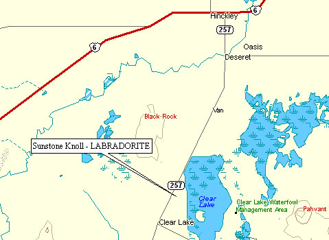
Our first destination was Sunstone Knoll, an area with pale yellow crystals of Plagioclase Feldspar. The decorative variation of this mineral is called Labradorite, and yellow Labradorite is “Sunstone.”
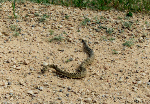
We found this slightly-less-than-friendly Utah resident on the road leading up to Sunstone Knoll. With all of our wanderings in the wilderness areas of the desert southwest, we have come across rattlesnakes on 5 or 6 occasions, but never had any problems. Hollywood westerns aside, in order to get bitten by a rattlesnake you basically have to corner it and torment the heck out of it. At that point, you probably deserve to be bitten.
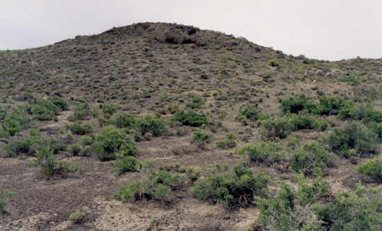
Here is Sunstone Knoll. It’s a small extinct volcanic cinder cone covered with chunks of Basaltic Lava large and small.
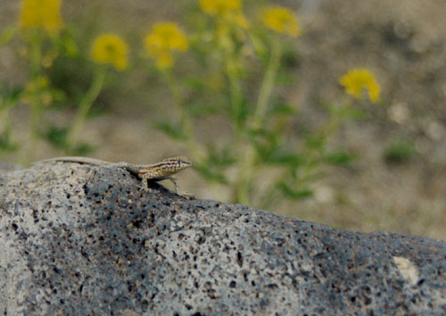
The Sunstone Labradorite shows up as pale yellow crystals embedded in the Basalt. You can see one here 6 inches or so to the right of Mr. Lizard.
Here is a better view of the Labrodorite crystals – the one on the right is about 3/4 inch long and that’s about as big as they get here. Those embedded in the Basalt are virtually impossible to get at as the Basalt is very hard and the crystals very brittle. Fortunately, the crystals weather out and can be found scattered in the dirt throughout the area.
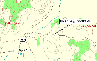
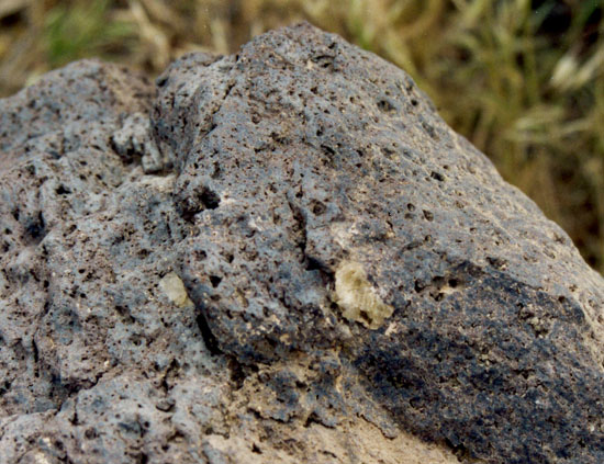
About 30 miles south of Sunstone Knoll, is an area in the Black Rock desert that is just littered with Obsidian. Most of it is plain black, but there is some nice red mixed in and plenty of the snowflake variety. The latter is caused by inclusions of Feldspar or Cristobalite that grow radial crystals in the still molten obsidian.
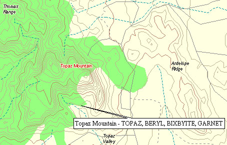
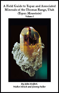
Our final stop for the day was Topaz Mountain. About 35 miles northwest of Delta, UT, it is the last mountain on the south end of the Thomas Range. The mountain is all light gray Rhyolite with many cavities. Some of these are lined with Topaz, Red Beryl, and Bixbyite. If you visit this area, plan to spend at least a full day here (we only had a few hours), and look into getting a copy of this book (ISBN 0967492009).
That evening we headed back into Nevada on highway 6. We had originally planned to stay in Belmont, NV – a ghost town with a bed & breakfast! But the innkeepers were out of town that week, leaving the town with a population of less than 10. So we continued on to Tonopah, NV, where we stayed at the Jim Butler Motel.
May 17th
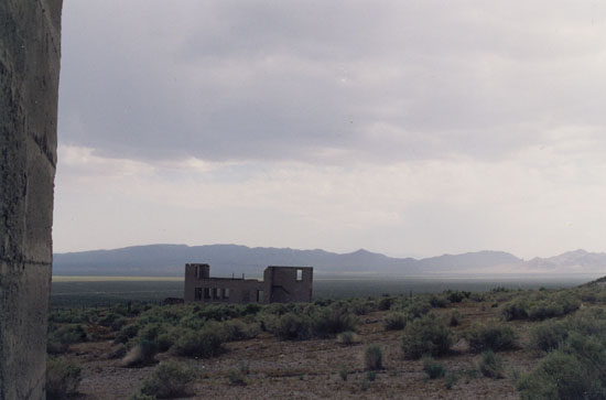
After breakfast in Tonopah, we headed south for bit on US 95 and then west on Nevada 266 towards the town of Lida and then California. Along the way is the ghost town of Palmetto, so named because the first miners to camp here in the 1860’s thought the local Joshua trees were related to palms.
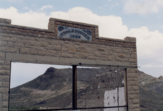
One of the few remaining buildings above. At it’s peak in 1906 the population was 200 and the main street had stores, saloons, feed yards, bakeries, restaurants, a bank, a doctor’s office, a newspaper and a post office.
The ore began giving out in late 1906 and the population began to dwindle as miners moved on to better digs (literally!). The remains of the original mill are pictured here, behind the historical marker.
The only remaining resident of Palmetto.
Just a couple miles west of Palmetto the Sierra Nevada mountains in California come into view on the horizon. In mid-May the temperatures in the Owens Valley, in the foreground, are already above 100°, but there is still snow on the mountains.
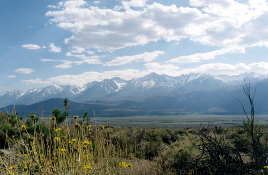
Here is a better view of the Sierra Nevada, which translates as “high and snow-covered.” One of the more accurately named mountain ranges.
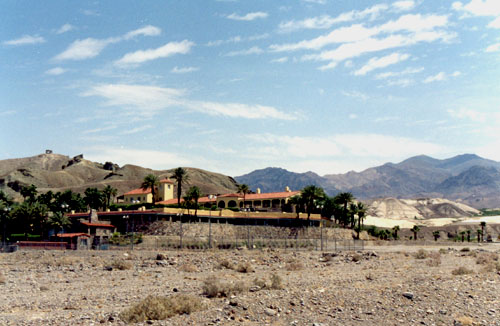
We continued on down the Owens Valley and took highway 190 over the Towne Pass and into Death Valley. This is the Furnace Creek Inn where we stayed for the next two nights. It was originally the crew quarters for the Pacific Coast Borax Company and in 1927 it was converted to a winter resort for well-to-do residents of Los Angeles. It was expanded and refurbished several times over the next several years and has been a resort ever since, except for a short closure during World War II.
May 18th
This morning we started off by taking the road up to Dante’s View. This spot in the Amargosa Mountains is at 5,475 feet, which puts it over 5,700 feet directly above Badwater. It averages about 30° cooler here than on the salt pan below.
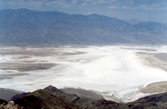
In this view you can see the salt pan on the valley floor and the Panamint Mountains on the far side. These reach all the way to up 11,000 feet. Mountains this size anywhere else in the world usually have a base that is at least five or six thousand feet, so the mountain only stands five or six thousand feet above you. Here, you can stand at almost 300 feet below sea level and look at all 11,000 feet in one grand view. Needless to say, it is an impressive sight.
Here is the view down on the salt pan. Summer heat dries out the salt on the surface, creating cracks. These surface cracks allow more water from the mud beneath to evaporate. This increases the salt level in the area of the crack, which swells up causing a “pressure ridge.”
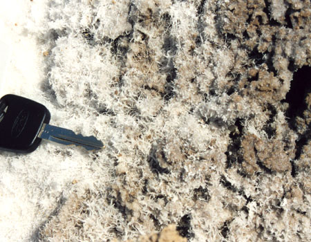
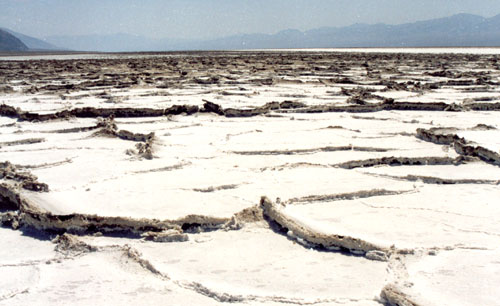
In some areas on the valley floor, the salt can form fine thread-like crystals. (Car key for scale)
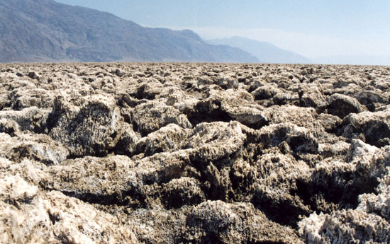
Devil’s Golf Course is an area of the valley floor that lies atop mixed clay and salt beds over 1,500 feet thick. Runoff from the surrounding mountains eventually finds it’s way into this deep bed. Surface evaporation draws the deep water up bringing dissolved salt with it. When it gets to the surface, the salt gets extruded into sharp, hard pinnacles up to two feet tall.
May 19th
Our last day in Death Valley, we drove out towards Nevada to visit the ghost town of Rhyolite.
Founded in 1905, the town reached a peak population of just under 10,000 and had four newspapers and three railroads. The twelve mines in the surrounding hills provided $3.1 million of gold (just over $65 million in today’s dollars). The largest of these, the Montgomery Shoshone mine and mill, was bought by Charles Schwab in 1906 for $5 million (Schwab, the founder of Bethlehem Steel, not the stock broker).
The financial panic of 1907 spurred a rapid decline in Rhyolite. Gold production petered out by 1908, and by 1910 the population had dropped to 675. The last mine and mill were closed in 1911, and the power and lights in Rhyolite were turned off in 1916.
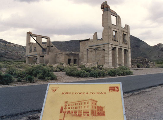
The last nail in Rhyolite’s coffin was driven in 1922 when gold was discovered across Death Valley in the town of Skidoo. The buildings in Rhyolite were, for the most part, not victims of time. The last few residents of Rhyolite dismantled the buildings and took the materials with them when they packed their wagons for Skidoo.