May 10th
Melissa was already in L.A. for a trade show, so I flew out and joined her there.
After a quick lunch we took interstate 15 out into the high desert.
The first stop was an old mining area just outside Barstow, CA. There were several shafts and entrances in the vicinity, but the only name I could find for the area was the name of the nearby hill – Lead Mountain.

We stopped on the approach road to the hill, as we saw what looked like a couple small tailings piles off to the left of the road. Here you can see the hill itself just beyond the truck, and one of the small dumps on the left side of the photo.

Next to the nearest dump was a prime example of why you need to be careful when exploring old mining regions. This shaft went down about 40 feet and was not marked or fenced in any way. Imagine “stumbling across” this at night! Shafts like this are all over the desert southwest. You can just make out the remains of a wooden cover on the bottom right of the hole. Just above the hole is a patch of Malachite about a foot across.

Here is a close-up near the shaft. The matrix looks like Barite, with individual crystals about 1 to 3 inches. The green specks are Malachite.

It was already mid-afternoon since we got a fairly late start out of L.A., so we only made one other stop this day. Just beyond Barstow on interstate 15 towards Las Vegas is the Calico ghost town. The ghost town itself is a tourist trap – don’t bother. But the Calico hills behind it got their name from the many colors of soil, thanks to heavy mineralization. This is the approach to the hills from interstate 15.

Up behind the hills, quite a ways from Calico, is the REAL ghost town – the remains of Borate, CA. This was the major Boron source in the U.S. before the discovery of larger deposits in Death Valley. The discovery of huge deposits in what is now Boron, CA put an end to the 20-mule teams in Death Valley, and in a similar fashion, it was Death Valley that put an end to Borate, CA.

You can see the various hues in the soil in this photo. The dirt had small Colmanite and Ulexite crystals throughout.

May 11th
After an overnight stay in Primm, NV (right at the CA-NV state line) we headed back into CA on interstate 15. The first stop was the Blue Bell mine, just to the west of Baker, CA.

A long twisting road went north from the interstate and snaked up into the hills where the mines were located. We passed the remnants of a mill in the valley between two mountains. Each mountain appeared to have tailings piles on the sides, but only one seemed to have a road heading up to it.

Here we are at the end of the road. You can’t tell from this picture, but we are actually perched on the side of a mountain (check two pics down), the road up was quite entertaining. Not visible behind the truck is the mine entrance. There wasn’t much to be found in the tailings piles and it turned out that the “mine” was just a prospect hole – it went back about 30 feet and that was it. Looks like we picked the wrong mountain.

Melissa coming out of the prospect hole. About all we found here was Dendridic Pyrolusite. There is supposed to be Fluorite in the area, but we only explored this one hole. Note the hardhat – exploring old mines can be dangerous. In fact, we rarely go underground and usually just explore the tailings piles on the surface.
In general, don’t enter old mines! Especially if you don’t have the proper equipment and are not experienced at this sort of thing. Ideally, you should be familiar with the specific details of the exact mine you are entering. The hazards are numerous and often deadly, a few of them are as follows:
- Old mines often include vertical shafts that you will not spot until too late. They may be covered with wood that has rotted, and the wood is covered with dirt. It looks just like the floor until you step on it. We have seen shafts 900 feet deep that are not marked in any way!
- Never, under any circumstances, enter any mine that has timber supports! Shoring an adit (a horizontal shaft) was very troublesome, time consuming, and expensive – how many tall trees do you see in the desert? All this wood had to be trucked in. Therefore, it was only done when the rock was far too unstable to support it’s own weight. Shored mines were dangerous for the miners that worked them and cave-ins were frequent. That was back when the mine was operating – add 100 years of erosion and wood rot and you get the picture.
- Assorted animals call abandoned mines home. Not the least are poisonous rattlesnakes, scorpions and black widow spiders. Rodents abound as well and rodent droppings in many parts of the American southwest are known to carry Hantavirus – which can cause death 24 hours after symptoms appear.
- If the mine is not well ventilated, various toxic gases can build up in the lower depths. Radon, Carbon Monoxide, and Hydrogen Sulfide, among others.

Here is the view looking out from where we parked. You can faintly see the road we came up, in the valley. In the distance is Soda Lake (dry) and the Bristol mountains beyond. For our next stop, we went in roughly that direction (south), and past the Bristol mountains to Amboy and Bristol Dry Lake.

Amboy is not much of a town. There is a restaurant that is out of business and that’s about it. Amboy Crater, an extinct volcano, is just to the southwest, so we decided to check it out.

Well, this is as close as we could get to the crater with the truck. There is a road that goes all the way there — can you see it in this photo? No, it’s not the faint line on the side of the cinder cone, it’s actually the rock and dirt right in front of you. Don’t worry if you can’t see the road, neither could we. And all this black stuff in the foreground is hard lava rock — not fun to drive on. So we gave up on Amboy Crater and traveled on to Bristol Dry Lake looking for interesting saline minerals.

Most dry lakes in the desert southwest are just dust and dirt, sometimes with a thin alkaline coating. But a few, like Bristol Dry Lake, have a deep salt bed that contains all the rich variety of minerals that were once dissolved in an ancient saltwater sea. This salt bed can be anywhere from a few feet to hundreds of feet thick, depending on the extent of the original ocean and the degree to which alluvium from the surrounding mountains has mixed with and buried it.

Here we are beside an evaporation trench. The salt bed here is thick enough to permit mining of a sort. They dig long furrows in the lake bed with a backhoe to expose a salt-lined trench. Then the trench is then flooded to dissolve the salt away from the dirt. As the brine evaporates, pure Halite crystals form, which are then harvested for the salt.

This is the view looking down into the brine pool, the center area is about 15 feet deep. The water is so clean, you can’t really see the surface, but that large table of salt in the bottom center is about 2 feet underwater. The best Halite crystals form on the undersides of the overhanging edges of the pool.
This was our last stop for the day, as we had about 170 miles to get back to our hotel in Primm, NV. The plan for tomorrow is to head due north from Primm and approach Mt. Potosi from behind on the back roads through Goodsprings, NV. Then we’ll head into Las Vegas where we will be staying tomorrow night.
May 12th
Today we took interstate 15 a short way north from Primm to the Jean/Goodsprings exit. Jean is right on interstate 15 so for a long time it was the “first chance” spot for Californians to lose their money in Nevada. But, it’s ten miles from the state line, a situation no enterprising Nevada businessman could live with for very long. So they built three large hotel/casinos right on the state line, an area which is now Primm, NV.

Goodsprings, a few miles north of the freeway, is a ghost town that never quite finished dying. There was once a thriving mining community here and after the mines gave out a few people decided to stay. The 2000 census lists the population at 232.
From Goodsprings we took state highway 53 north. Don’t let the official sounding name fool you – from the edge of town it’s 16 miles of butt-bruising dirt road to Mt. Potosi – not an inch of pavement in sight. It must have been a fairly damp early spring as a lot of the cactus was in bloom along the way.


Eventually we made it to our destination, only slightly worse for the wear.

The mine itself is high up the mountain at the base of the cliff face. You can see the mine’s tailings pile towards the left side of the cliff – in a straight line up from the rear tire of the truck. The area along the cliff further to the right is a popular spot for rock climbing.

There is also an extensive underground cavern called “Pinnacle Cave” about a half mile north of this spot. Local spelunkers in Las Vegas wisely keep the exact location of the entrance secret so that it is only known to those that will properly care for the caves.
In other tidbits of Mt. Potosi news… This was where actress Carole Lombard died on January 16, 1942.

According to reports, the plane was off course because the captain was in the back talking to Lombard and the first officer was up front flying all alone in instrument conditions. The plane clipped a rocky ledge on Mt. Potosi, flipped into the face of a cliff, and exploded.
Since they were on a war-bond promotion tour, Lombard’s death was considered the first war-related female casualty that the U.S. suffered during World War II. A few remaining parts of the DC-3 can still be found high up on the mountainside.

Here is a much better photo showing the mine and its very extensive tailings.
Potosi was a lead mine founded by Mormon settlers in 1856. Ore from the mines was hauled to Las Vegas where it was smelted in a crude furnace said to be the first smelter built and operated west of the Missouri River. Lead from Potosi Mine was used for bullets and other items by Mormon settlers as far away as Salt Lake City, Utah.
The extreme age of this mine leads to a tremendous amount of interesting minerals on the dumps. Modern mining techniques extract every last bit of ore, but back in the 1850’s the miners just broke the rock by hand, kept the good parts and tossed the remainder on the dump pile. This method of separating worthless minerals from desired minerals was called “hand cobbing” and it was terribly inefficient. In many places, fortunes have been made just by re-processing the dump piles using better techniques. For example, the Vulture Mine near Wickenburg, AZ produced gold from 1863 to 1942, resulting in about 240,000 tons of tailings. In 1991, a company leased the rights to reprocess them. They got through about half the tailings pile, and netted $3.2 million in gold.
The tailings pile here at Potosi consists primarily of Limestone and white Calcite with silvery-grey Galena. Nice patches of Azuite and Malachite are mixed in along with Sphalerite and other minerals, as well as quite a few fossils.

Here is the view looking southwest away from the base of Mt. Potosi along the western slope of the Spring Mountains and towards California.
The ride into Las Vegas passed without event. We stayed the night at the Luxor.
May 13th
Just did some general sightseeing today (Lake Mead, Hoover Dam, etc.). We went rockhounding again on the 14th.
May 14th
After two evenings in Las Vegas, we headed north on interstate 15 towards Utah.

Our only stop along the way was near the Valley of Fire state park. This region of twisted red sandstone is pretty cool, but we were looking for a seam of purple opal-like Chalcedony just outside the park.

The road approaching our target passed through some sandstone formations like the ones in the park proper, but these lack the deep red hue.

Some of the red sandstone crops out here near the base of the mountains. The heart of Valley of Fire is nothing but this red sandstone, most of it eroded into incredible, surreal shapes.

We arrive at the Chalcedony area. This is from the ledge containing the seam, looking back towards the truck and the road.

The seam of Chalcedony varies from 3 inches to over 4 feet in width. It runs for about 100 feet along the center of the ledge face and then comes out on top of the ledge for another 30 feet or so. Here you can see the seam with Chalcedony nodules that are cracked in half. The largest here is about 4 inches long.

In this section the seam is well-exposed and some whole nodules are indicated by the arrows. These are smaller pieces about 1 inch in diameter. It is very hard to extract whole nodules as they are quite brittle and the matrix is hard volcanic material – probably Rhyolite, but I didn’t check too closely.
This was our only stop today. The rest of the day was spent on the road driving up to Sterling, UT where we will be staying for the next two nights at the Cedar Crest Inn.
May 15th
Our first trip in Utah was halfway across the state on interstate 70 to the town of Green River. We had directions to a spot just to the south of town where Amethyst and Celestite-filled geodes were to be found. I’m not sure if it was us or the directions, but we never found the spot. There was some pretty spectacular scenery along the way though.


After working our way back across the state, we started exploring the region around Marysvale, UT.

This was a very active mining district and our first stop was an abandoned gold mine. The USGS listing for this mine included a wide array of minerals, so we parked in a small gulch with a number of adits and tailings visible and started looking around.

The nearest adit is just up that dirt road on the right wall of the gulch. However, we were not fully prepared for what we found there…

Now, bars blocking up old mine entrances are fairly common – Radiation warning signs are not so common! Here is a close-up so you can read the sign.

Needless to say, we got the hell out of there immediately! Interesting to note, the USGS records, which are usually very accurate, made absolutely no mention of Uranium mining here.
We did hit one other area near Marysvale, about 3 miles southwest of the radiation area. This was a region of scattered Rhyolite boulders spread out along highway 89 for about 1/2 mile. Most of the boulders contain small pockets lined with Amethyst and cubical Bixbyite crystals. All of the individual crystals were quite small (1-5 mm), but perfectly formed.
May 16th
This morning we headed west from Sterling, UT, planning to hit a spot with yellow Labradorite, another with Snowflake Obsidian, and finally visit Topaz mountain near Delta, UT before heading back into Nevada to stay the night.

We took a few back roads to get over the Valley Mountains towards our rockhounding sites for the day. This is the view from Lone Cedar Pass looking west to the Pavant Range. Scipio Lake can be seen in the valley.
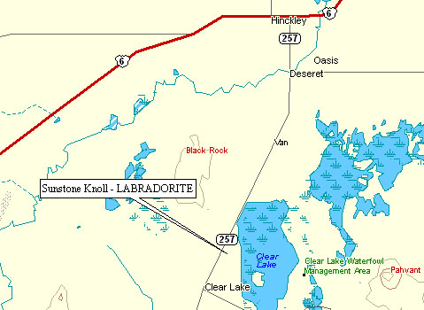
Our first destination was Sunstone Knoll, an area with pale yellow crystals of Plagioclase Feldspar. The decorative variation of this mineral is called Labradorite, and yellow Labradorite is “Sunstone.”
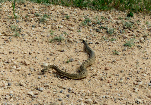
We found this slightly-less-than-friendly Utah resident on the road leading up to Sunstone Knoll. With all of our wanderings in the wilderness areas of the desert southwest, we have come across rattlesnakes on 5 or 6 occasions, but never had any problems. Hollywood westerns aside, in order to get bitten by a rattlesnake you basically have to corner it and torment the heck out of it. At that point, you probably deserve to be bitten.
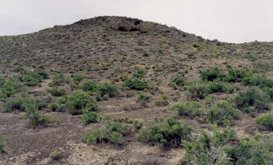
Here is Sunstone Knoll. It’s a small extinct volcanic cinder cone covered with chunks of Basaltic Lava large and small.
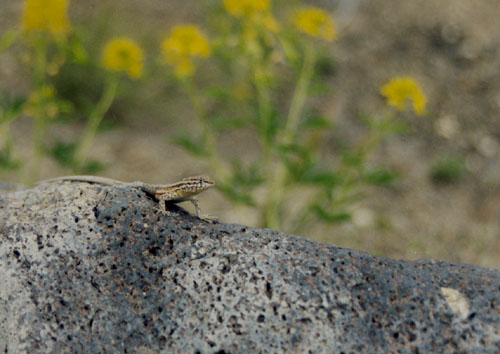
The Sunstone Labradorite shows up as pale yellow crystals embedded in the Basalt. You can see one here 6 inches or so to the right of Mr. Lizard.
Here is a better view of the Labrodorite crystals – the one on the right is about 3/4 inch long and that’s about as big as they get here. Those embedded in the Basalt are virtually impossible to get at as the Basalt is very hard and the crystals very brittle. Fortunately, the crystals weather out and can be found scattered in the dirt throughout the area.
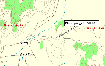
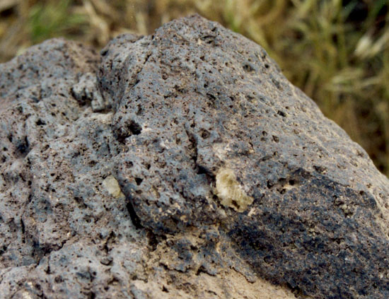
About 30 miles south of Sunstone Knoll, is an area in the Black Rock desert that is just littered with Obsidian. Most of it is plain black, but there is some nice red mixed in and plenty of the snowflake variety. The latter is caused by inclusions of Feldspar or Cristobalite that grow radial crystals in the still molten obsidian.
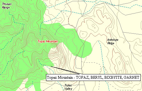
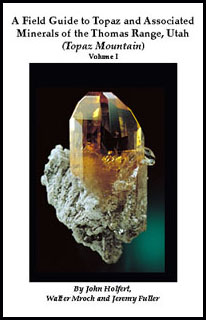
Our final stop for the day was Topaz Mountain. About 35 miles northwest of Delta, UT, it is the last mountain on the south end of the Thomas Range. The mountain is all light gray Rhyolite with many cavities. Some of these are lined with Topaz, Red Beryl, and Bixbyite. If you visit this area, plan to spend at least a full day here (we only had a few hours), and look into getting a copy of this book (ISBN 0967492009).
That evening we headed back into Nevada on highway 6. We had originally planned to stay in Belmont, NV – a ghost town with a bed & breakfast! But the innkeepers were out of town that week, leaving the town with a population of less than 10. So we continued on to Tonopah, NV, where we stayed at the Jim Butler Motel.
May 17th
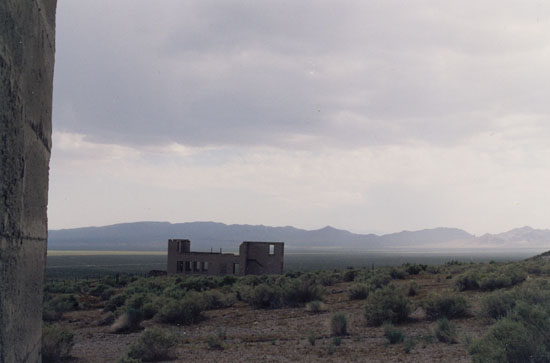
After breakfast in Tonopah, we headed south for bit on US 95 and then west on Nevada 266 towards the town of Lida and then California. Along the way is the ghost town of Palmetto, so named because the first miners to camp here in the 1860’s thought the local Joshua trees were related to palms.
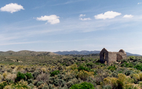
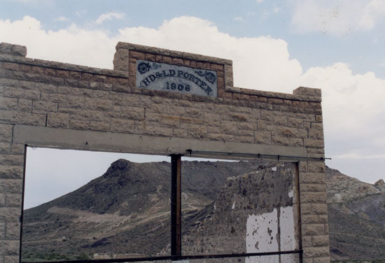
One of the few remaining buildings above. At it’s peak in 1906 the population was 200 and the main street had stores, saloons, feed yards, bakeries, restaurants, a bank, a doctor’s office, a newspaper and a post office.
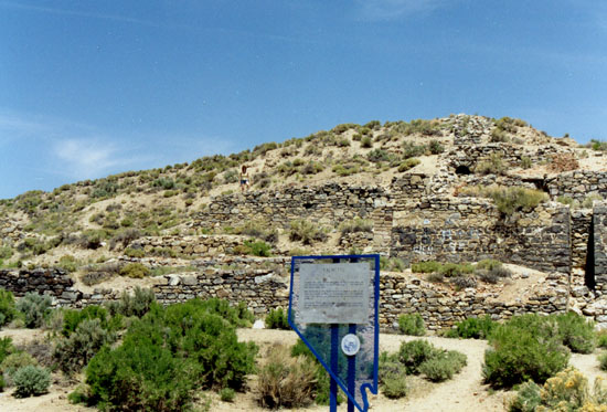
The ore began giving out in late 1906 and the population began to dwindle as miners moved on to better digs (literally!). The remains of the original mill are pictured here, behind the historical marker.
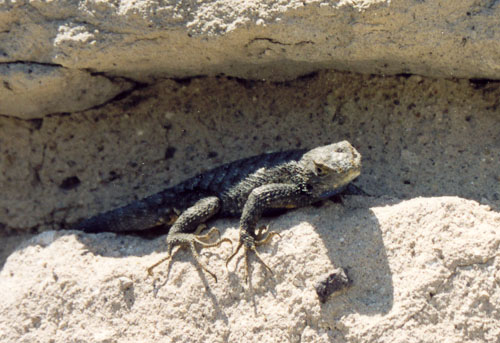
The only remaining resident of Palmetto.
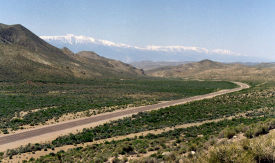
Just a couple miles west of Palmetto the Sierra Nevada mountains in California come into view on the horizon. In mid-May the temperatures in the Owens Valley, in the foreground, are already above 100°, but there is still snow on the mountains.
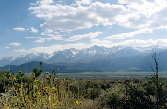
Here is a better view of the Sierra Nevada, which translates as “high and snow-covered.” One of the more accurately named mountain ranges.
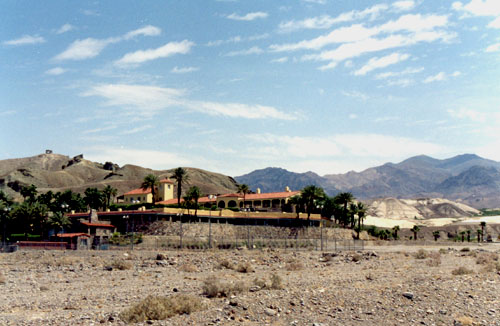
We continued on down the Owens Valley and took highway 190 over the Towne Pass and into Death Valley. This is the Furnace Creek Inn where we stayed for the next two nights. It was originally the crew quarters for the Pacific Coast Borax Company and in 1927 it was converted to a winter resort for well-to-do residents of Los Angeles. It was expanded and refurbished several times over the next several years and has been a resort ever since, except for a short closure during World War II.
May 18th
This morning we started off by taking the road up to Dante’s View. This spot in the Amargosa Mountains is at 5,475 feet, which puts it over 5,700 feet directly above Badwater. It averages about 30° cooler here than on the salt pan below.
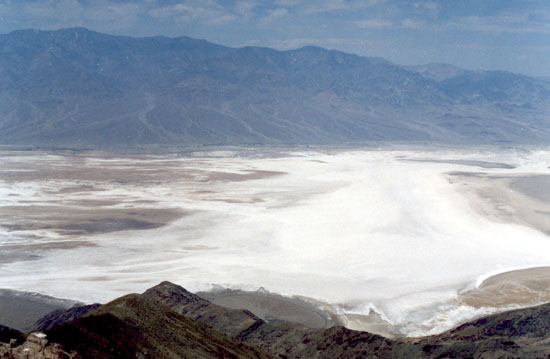
In this view you can see the salt pan on the valley floor and the Panamint Mountains on the far side. These reach all the way to up 11,000 feet. Mountains this size anywhere else in the world usually have a base that is at least five or six thousand feet, so the mountain only stands five or six thousand feet above you. Here, you can stand at almost 300 feet below sea level and look at all 11,000 feet in one grand view. Needless to say, it is an impressive sight.
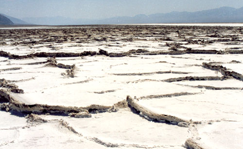
Here is the view down on the salt pan. Summer heat dries out the salt on the surface, creating cracks. These surface cracks allow more water from the mud beneath to evaporate. This increases the salt level in the area of the crack, which swells up causing a “pressure ridge.”
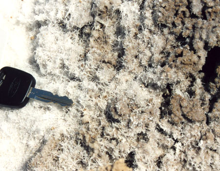
In some areas on the valley floor, the salt can form fine thread-like crystals. (Car key for scale)
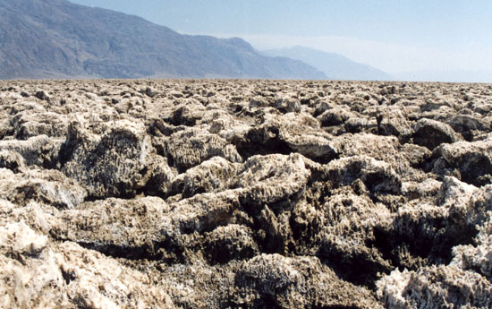
Devil’s Golf Course is an area of the valley floor that lies atop mixed clay and salt beds over 1,500 feet thick. Runoff from the surrounding mountains eventually finds it’s way into this deep bed. Surface evaporation draws the deep water up bringing dissolved salt with it. When it gets to the surface, the salt gets extruded into sharp, hard pinnacles up to two feet tall.
May 19th
Our last day in Death Valley, we drove out towards Nevada to visit the ghost town of Rhyolite.
Founded in 1905, the town reached a peak population of just under 10,000 and had four newspapers and three railroads. The twelve mines in the surrounding hills provided $3.1 million of gold (just over $65 million in today’s dollars). The largest of these, the Montgomery Shoshone mine and mill, was bought by Charles Schwab in 1906 for $5 million (Schwab, the founder of Bethlehem Steel, not the stock broker).
The financial panic of 1907 spurred a rapid decline in Rhyolite. Gold production petered out by 1908, and by 1910 the population had dropped to 675. The last mine and mill were closed in 1911, and the power and lights in Rhyolite were turned off in 1916.
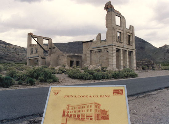
The last nail in Rhyolite’s coffin was driven in 1922 when gold was discovered across Death Valley in the town of Skidoo. The buildings in Rhyolite were, for the most part, not victims of time. The last few residents of Rhyolite dismantled the buildings and took the materials with them when they packed their wagons for Skidoo.
Enjoyed this trip dialogue.
Thank you
I really enjoyed reading this. More, please! If you want to share your maps for this trip, you would be my new best friend!
Thanks!
Laurie
excellent info, learned a great deal.superb pictures.Radiation? gieger counters are avail to general public. no suprise govt info not accurate. from what you stated on minerals you’re either a pro or very dedicated. either way thank you it was fun
Funny…I’ve been to each of these sites. The snake is a green mojave, one nasty critter. This snake is the most deadly in America. Came across one at fish springs going to the geode beds at Dugway. Anyway enjoyed the web page…thanks.
Great information and pics. However, there is an easier way to drive close to the Amboy Crater. The entrance if off of National Trails Highway (the road that takes you through the town of Amboy). The entrance is a dirt road that is to the north of the crater. There is a big BLM sign at the entrance.
Thank You for the interesting and educational writing as well as the great photography. Having seen your love of the desert, have you considered taking the Mojave Road while vehicle travel is still allowed? It’s about 140 miles of historic trail that I think you would enjoy. We have a group from our church going the first weekend in Dec. I suspect you would no doubt add a lot to the info available. Randy
Great trip – and a great blog. I do films and touring guides on this entire region. Check out http://www.goldcreekfilms.com — Thanks for writing this blog – not much has changed since 2001. You may want to revisit Tonopah – the old Mizpah hotel is re-opened and the Tonopah Historic Mining Park has some new cool additions like signs, videos and brochures. I’ve been meaning to get to Goodsprings – and your journey and maps and pics were great. Thanks for sharing! Ted